Pessimism and Hope When Teaching Global Environmental History

First published in early June on ActiveHistory.ca

Wendell Berry stands before the solar panels on his farm in Henry County, KY. Photo by Guy Mendes (From Wikipedia)

By Jim Clifford

This past year I taught a small but fantastic group of undergraduate students in a course focused on the global environmental history of the industrial revolution. My goal in the course was to situate the massive environmental transformations of the past two centuries in a broad historical context and to provide an opportunity to discuss the benefits and costs of these changes. By the end of the course, however, it became clear that the students recognized the unsustainable nature of the global economy and that they were unconvinced that the more positive and sustainable developments in recent decades would meet the challenge of climate change.

We started the course by exploring global trade and connections from 1400 through to about 1800, recognizing the importance of China and Asia more generally during this time period. From there we explored the ongoing debates about the reasons the industrial revolution started in Britain. With that broad context established we explored some of the environmental consequences of industrialization and globalization over the past two hundred years. This included attention to the colonial disposition, resource depletion and widespread deforestation resulting from the reliance of industrial economies on on raw materials from forests, plantations, mines and guano islands scattered throughout the world. We explored a range of developments with significant environmental consequences, such as the application of industrial technology to fishing and whaling, leading to the collapse of whale populations and once productive fisheries, through to the extractive industries that harvested mahogany, cinchona and gutta percha from tropical forests in South America and South East Asia.

Database and Visualisations Launched

From the Trading Consequences Blog: Today we are delighted to officially announce the launch of Trading Consequences! Over the course of the last two years the project team have been hard at work to use text mining, traditional and innovative historical research methods, and visualization techniques, to turn digitized nineteenth century papers and trading records (and their OCR’d text) into a unique database of commodities and engaging visualization and search interfaces to explore that data. Today we launch the database, searches and visualization tools alongside the Trading Consequences White Paper, which charts our work on the project including technical approaches, some of the challenges we faced, and what and how we have achieved during the project. The White Paper also discusses, in detail, how we built the tools we are launching today and is therefore an essential point of reference for those wanting to better understand how data is presented in our interfaces, how these interfaces came to be, and how you might best use and interpret the data shared in these resources in your own historical research. READ MORE


tallowimage

Did the Steam Engine or Spinning Mule lead to the Industrial Revolution?

From Wikipedia "The introduction of the Spinning Mule into cotton production processes helped to drastically increase industry consumption of cotton. This example is the only one in existence made by the inventor Samuel Crompton. It can be found in the collection of Bolton Museum and Archive Service." Image by Pezzab.
From Wikipedia “The introduction of the Spinning Mule into cotton production processes helped to drastically increase industry consumption of cotton. This example is the only one in existence made by the inventor Samuel Crompton. It can be found in the collection of Bolton Museum and Archive Service.” Image by Pezzab.

[First published on ActiveHistory.ca]

I recently introduced a group of students to this question by asking them to listen to an episode of In Our Time from BBC Radio 4. After about ten minutes of background conversation the episode devolves into an ongoing argument between the host, Melvyn Bragg and Pat Hudson, one of the leading historians of this time period. The dispute begins when Hudson refuses to focus on the role of innovative Britons in developing new technology that triggered industrialization. Instead, she insists on discussing the underlying environmental and global economic factors that made it possible for Britain to sustain long-term economic growth. This was not the explanation Bragg wanted to focus on and he begins to debate Hudson, demanding that she give British culture its due:

Bragg: … Oh it’s all to do with the broad sweep of history. Listen people invented things that hadn’t been there before which enabled things to happen that had not happened before.

Hudson stood her ground and tried in an increasingly tense conversation to explain why historians moved away from this traditional interpretation of the history of the industrial revolution. In doing so, she comes close to calling the host a racist:

Hudson: Can I say that that really does characterise nationalistic accounts of the period with a peculiar sort of emphasis on British genius or…

Bragg: I didn’t say that!

Hudson: Or the superiority of the British as a race, this characterises some really almost racist accounts of the Industrial Revolution…

Bragg: OH NO! COME ON—THAT’S RUBBISH!![1]

Timeline.js Test


I’ve just learned about a great timeline creation tool called Timeline.js. It is a very easy tool to create nice looking and very functional timelines. There is a small problem, as the current Google spreadsheet template does not work with dates before 1900 (a common problem with computer data fields). However, those of us interested in pre-1900 history can simply cut and past the top row of that template into a fresh spreadsheet, the timeline works fine with all dates (use a negative for dates before the year zero). I’ve created a very quick and rough timeline of the global tallow supply below. I will fix it up over the next few hours. I think this could be a great tool for undergraduate teaching. Here is what the Google spreadsheet looks like:

spreadsheet

Github as a HGIS portal?

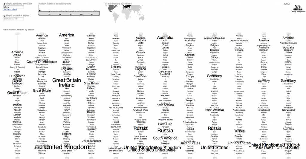
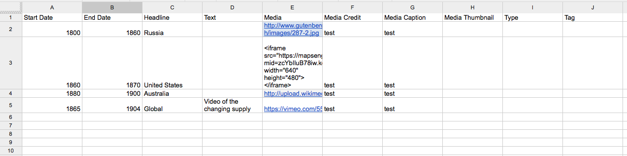
I’ve been a part of a lot of discussions lately about the need for an effective way to  share HGIS data. As the number of researchers using GIS for history/historical geography increases, the need to find ways of sharing resources and avoiding duplicated efforts also increases. One way forward is for more of us to post our data on individual websites (see the Don Valley project). We could then try to link the data together through some kind of federated search portal (like NINES.org). Ideally, however, it would be nice to have a system where individuals and teams could collaborate on work in progress or expand upon data created by others then share it again. Simple websites don’t provide an easy way for people to upload data back to the source. Github provides a platform for sharing code and a system for collaboration. It is widely used by the open-source software community. I’ve created a test repository and it seems like it is possible to share a few different kinds of vector data, including shapefiles, KML and geojson, all of which work with QGIS (and some work with ArcGIS). Is this an established platform that we could attempt to adapt to the needs of the HGIS community? Or is Git too confusing and difficult and the soft limits of 100 MB per file and 1 GB per repository too small for our needs? Do we need a system where we can also share scanned and georeferenced maps? Is there another existing option that we could agree on or do we need to wait until someone has the time, skills and funding to build something better suited to our needs?

Text Mining 19th Century Place Names

By Jim Clifford

Nineteenth century place names are a major challenge for the Trading Consequences project. The Edinburgh Geoparser uses the Geonames Gazetteer to supply crucial geographic information, including the place names themselves, their longitudes and latitudes, and population data that helps the algorithms determine which “Toronto” is most likely mentioned in the text (there are a lot of Torontos). Based on the first results from our tests, the Geoparser using Geonames works remarkably well. However, it often fails for historic place names that are not in the Geonames Gazetteer. Where is “Lower Canada” or the “Republic of New Granada“? What about all of the colonies created during the Scramble for Africa, but renamed after decolonization? Some of these terms are in Geonames, while others are not: Ceylon and Oil Rivers Protectorate. Geonames also lacks many of the regional terms often used in historical documents, such as “West Africa” or “Western Canada”.

To help reduce the number of missed place names or errors in our text mined results, we asked David Zylberberg, who did great work annotating our test samples, to help us solve many of the problems he identified. A draft of his new Gazetteer of missing 19th century place names is displayed above. Some of these are place names David found in the 150 page test sample that the prototype system missed. This includes some common OCR errors and a few longer forms of place names that are found in Geonames, which don’t totally fit within the 19th century place name gazetteer, but will still be helpful for our project. He also expanded beyond the place names he found in the annotation by identifying trends. Because our project focuses on commodities in the 19th century British world, he worked to identify abandoned mining towns in Canada and Australia. He also did a lot of work in identifying key place names in Africa, as he noticed that the system seemed to work in South Asia a lot better than it did in Africa. Finally, he worked on Eastern Europe, where many German place names changed in the aftermath of the Second World War. Unfortunately, some of these location were alternate names in Geonames and by changing the geoparser settings, we solved this problem, making David’s work on Eastern Europe and a few other locations redundant.  Nonetheless, we now have the beginnings of a database of  place names and region names missing from the standard gazetteers and we plan to publish this database in the near future and invite others to use and add to it. This work is at an early stage, so we’d be very interested to hear from others about how they’ve dealt with similar issues related to text-mining historical documents.