Author: Jim

Water Famine, Social Injustice, and River Failure

The conservative newspaper, the West Ham Guardian, roundly criticised the East London Waterworks Company (ELWC) for putting dividends before people after it was announced on August 22 of 1898 that West Ham, along with much of East London, was going to face another period of intermittent water supply.  The bundle of correspondence kept by the company, together with the local newspapers, make it clear that the majority of the public did not accept that the record low rain fall during the preceding year was the cause of the shortage.   Instead the public blamed the monopoly control of the ELWC for not investing the necessary capital to increase the water supply.  The population of West Ham had grown by over two hundred thousand people in the past two decades, but there was little reflection on the possibility that the urban growth east of London was overtaxing the capacity of the already strained water supply provided by the Lea.  Instead it was seen as another example of the wealthy failing to meet their obligations to the less fortunate.  In West Ham the anger that developed as a result of the water famine help unite the electorate behind a socialist led Labour Group in November 1898 elections, resulting in the first labour majority on a municipal council in Britain.  This paper will examine the politics of the 1898 water famine within the context of West Ham.
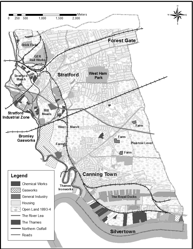
West Ham and the River Lea

West Ham was located east of London on the Essex side of the River Lea that formed the eastern border of London. The Lea was an important part of West Ham from the very beginnings of industrial growth in the area. Tidal mills harnessed the river for power and calico and silk printers relied on the purity of the water for their work. The river was also source of drinking water and used for sewage disposal. During the mid-nineteenth century chemical factories, a large railway engineering works and a shipbuilding works were built along the banks of the Lea and its back rivers in West Ham. These many uses of the river also started to come into conflict with each other. Pollution in the river forced the calico and silk printers to leave West Ham. Sewage in the water supply was identified as the main cause of the 1866 Cholera epidemic in East London. The diversion of too much water for drinking disrupted the other uses of the Lea, causing sewage and other wastes to collect in the otherwise drying river beds and disrupting the barge traffic that industry relied on to supply raw materials. The Lea was also a threat to the growing borough of West Ham as the suburb was mostly built on land below the natural high water mark of both the Lea and the Thames. The relationship between the industrial suburb of West Ham and the river Lea is the central topic of my dissertation. My second chapter, that I have now begun researching, looks at the water famines of 1895, 1896 and 1898 when the East London Waterworks Company restricted the water supply by turning off the flow of water to East London and eastern suburbs like West Ham for between 18 and 20 hours a day. I will post another blog entry focusing on these famines in a few weeks when I’ve done more of the research.

A Hybrid Landscape on the edge of London

Author Sherwell described London in 1901 as “a great, hungry sea, which flows on and on, filling up every creek, and then overspreads its borders, flooding the plains beyond” (Quoted in Roy Porter, London: A Social History). West Ham was one of these “flood plains”, beyond London’s borders, that was filled with urban growth in the second half of the nineteenth century. It was an atypical suburb; an early example of industrial migration from the urban core to the periphery, where manufacturing, not commuter bedroom communities, was the raison d’être for suburban growth. West Ham was the sixth largest city in England and Wales, but with the enormous shadow cast by the Metropolis, it was unclear whether the Borough was apart from or a part of London. The industrial landscape was a polluted landscape. Chemical factories, gasworks, sugar refineries, the Thames Ironworks shipbuilding yard, and the Great Eastern Railway works burnt a lot of coal, as did many of the households in the Borough. Yet West Ham was not an entirely urban-industrial landscape even at the end of the nineteenth century. The 1893-4 Ordinance Survey Maps list four farms (one of which was located beside the Bromley Gasworks and the other three in the east of the Borough on the Plaistow Marsh). In 1915 there were numerous allotment gardens that established an urban agriculture presence in West Ham at the height of industrial and residential growth. These sites of agriculture, along with the parks, recreation grounds, graveyards, undeveloped lands and open marshes coexisted with factories, commercial high streets, slums and better off suburb communities. The messy overlap between the city and the country is one of the reasons West Ham is so interesting. It was a hybrid landscape, an unplanned garden city, often under a cloud of smoke and noxious fumes, filled with hundreds of thousands of people, moving between factories, homes and gardens: people living in both the city and the country and in neither. West Ham was a borderland, a landscape of exposure, a tormented but not defeated rural environment. It was a riverine landscape (flood plains and marshlands), transformed by humans into an industrial one, but always threatened with the chance that the River Lea would reclaim its territory, at least for a moment.