Tag: River Lea

Cleaning the environmental and social conditions of the 2012 Olympic Park

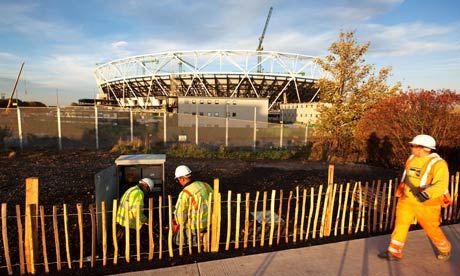
The clock is counting down to the start of the 2012 Olympics in London. The main Olympic Park [map] is located in East London in heart of the Lower Lea Valley, which happens to be the same place I studied in my recently completed PhD. My research demonstrated the close correlation between the degraded environmental conditions and the disadvantaged social conditions in the sections of West Ham built on the wetlands. I ended my dissertation wondering whether the current multi-billion dollar project to clean up the environment for the Olympics might result in a comparable effort to clean out the socially undesirable people from this landscape.

An article in the Guardian, “Houseboaters being ‘socially cleansed’ from Olympics area,” suggests this process might be underway. House boaters are concerned that British Waterways are going to increase the mooring costs along canals in the Lower Lea:

British Waterways, which manages 2,200 miles of canals and rivers, has put forward changes to the mooring rules on the river Lea, in east London, that could increase the cost of living on the waterway from about £600 to £7,000 a year. Residents see the move as a deliberate attempt to drive them away. A draft note from British Waterways on 6 December 2010, seen by the Guardian, says: “The urgency … relates to the objective of reducing unauthorized mooring on the Lea navigation and adjacent waterways in time for the Olympics.”

Photo Essay

Birds eye view of Thames Ironworks (Newham Story)

Two years ago I published a photo essay entitled “The Urban Periphery and the Rural Fringe : West Ham’s Hybrid Landscape” in a special environmental history issue of Left History (Spring/Summer 2008).  The issue is now online and I’ve uploaded the PDF of my essay here.  To see a lot more historical photos of West Ham take a look at the Newham Story website.

Olympic site begins to take shape, but the Lea remains polluted


http://www.guardian.co.uk/uk/2009/oct/30/stratford-london-2012-olympics

The Guardian published another article on the Olympic transformation taking place in West Ham.  Anna Kessel is impressed by the changes in the landscape and she looks forward to the time when the Lea is transformed into a more pleasant river.  Interestingly enough, she is not the first person to bemoan the condition of the Lower Lea and its back rivers that flow through the 2012 Olympic site.  In 1844, decades before the height of the industrial boom in West Ham, James Thorne, in his book Rambles by Rivers, talks about the Lower Lea and its degraded industrial condition:

But by this time our river has ceased to be either picturesque or interesting: lime-kilns, calico-printing, and distilleries are the most prominent objects along its banks; and however useful these may be, they are not agreeable to either nose or eye.

The River Lea’s modern pollution problems covered in the Guardian

Leo Hickman’s article on the current condition of the river Lea shows how little has changed since the rapid period of suburban and industrial expansion into its wetlands and river valley in the nineteenth century.

http://www.guardian.co.uk/environment/2009/oct/09/river-lee-polluted-source

Sadly, the problems identified in this article are not new.   The pollution of the Lea gained national attention a number of times in the second half of the nineteenth century.  

Early Industrial Development on the Lower River Lea

The development of railways [1839] and docks [1855] in the parish of West Ham corresponded with significant industrial development in the mix of wetlands and rural landscapes on London’s suburban fringe in the mid-nineteenth century.  That being said, the Lower Lea and the parish of West Ham had some industrial development centuries earlier.  Along side the early industry, human transformation of the physical landscape began with marsh reclamation for agriculture, which also started centuries before the suburban and industrial boom in the second half of the nineteenth century.  To fully understand the landscape transformation of the nineteenth century we need to better understand the long history of human labour that transformed the wetlands of the Lower Lea through to the early nineteenth century.

To accomplish this goal, I’ve been doing some work to map the early industrial transformation on the Lea, before the heavy industry began to arrive in the mid-19th century.   I found that the Lower Lea was a site of industry at the time of the Norman Invasion of England and the Domesday Book.  Millers on the Lower Lea used the tides to grind grain and other products.  These mills remained in place during the early nineteenth century and at least the Three Mills remained operational through to the twentieth century.  This long continuity of industry in the parish of West Ham foreshadowed the massive industrial growth in the second half of the nineteenth century.  New industries, such as Calico Printing in the eighteenth and early nineteenth centuries and then the chemical and animal rendering industries of the nineteenth centuries started near the old mill sites, before spreading along the banks of the Stratford Back Rivers.  The GIS map below provides a conservative estimate of the industrial footprint near Stratford High Street in 1810 .

Stratford Back Rivers Industry 1810

The Lea: A Suburban Industrial River, 1855-1915.

I am working on a paper about the transformation of the Lower Lea River (including the Bow Back Rivers and Bow Creek) into an industrial river network, during the second half of the nineteenth century and the early twentieth century.  As I write the paper I will be creating some GIS maps of the area from that I will post on this blog.  I’ve included the abstract for this paper below.  Here is a very early map of the rivers I’m researching.

Early GIS map of back rivers