Category: Uncategorized

Historical 2012 Olympic Tour (1st Edition)

British politicians and planners are using the 2012 Olympic games to “revitalize” the Lower Lea Valley, a post-industrial landscape, situated between four inner-suburban boroughs in the East of London, including West Ham, which was the focus of my dissertation research.

A century ago R. A. Bray described West Ham “as that of a spot somewhere near London to which people went with reluctance if they had business there, and from which they returned with joy as soon as the business was over.”[1] Sadly, I don’t imagine most people would describe it any differently today and most only know it as the home of a struggling football club.

Half a century of rapid industrial and population growth in the second half of the nineteenth century transformed the once green wetlands of the Lower Lea River and Thames Estuary into a dirty manufacturing suburb with a range of social problems that matched the extensive environmental decline. Despite this troubled history and the scarred landscape it left, I would suggest travelers to London should venture eastward and see a different side of London from the regal and imperial parks and buildings in Westminster. The Docklands Light Rail lines make it easy to travel through East London and they are above ground, so you can see where you are going. Most of the West Ham sites listed below are within walking distance of a DLR station.

View Olympic Neighbourhoods in a larger map

Podcast: An Environmental History of the Lower Lea River Valley, Site of the 2012 London Olympics

From ActiveHistory.ca:
The Lower Lea Valley, currently undergoing a massive redevelopment project in preparation for the next Summer Olympics, underwent a number of equally remarkable transformations as London’s heavy industry migrated to the city’s eastern periphery in the second half of the nineteenth century. In this talk, Jim Clifford explored some of the findings of his PhD dissertation on the environmental problems created by half a century of urban-industrial development, and the challenges this history poses for redevelopment.

His lecture, “From a Pastoral Wetland to an Industrial Wasteland, and Back Again? An Environmental History of the Lower Lea River Valley, the Site of the 2012 London Olympics,” is part of the pan-Canadian NiCHE Speakers’ Series and the Mississauga Library System’s ‘History Minds’ series.

Click here to listen to the talk.

Dissertation Defended

On January 20th I successfully defended my dissertation, “A Wetland Suburb on the Edge of London: a Social and Environmental History of West Ham and the River Lea, 1855-1914.”  Now I’ve just got the small job of converting it into a book ahead.  I’ve included the abstract for this project below. If anyone has suggestions on where I should try to publish an urban environmental history of London/West Ham, I’d be happy to hear them.

Abstract:
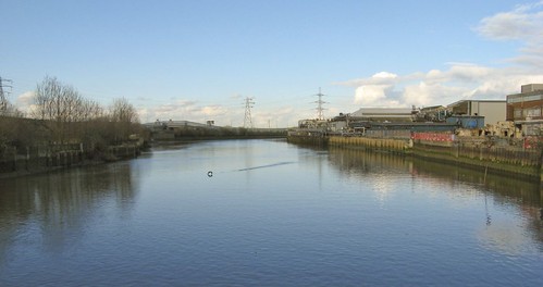
This dissertation examines the multifaceted connections between ecological change on the wetlands where the River Lea meets the Thames Estuary and the development of a young suburb on the edge of London. West Ham was a patchwork of heavy industry, rivers, slums, farmlands and low-lying marshes. The difficult environmental conditions of this wetland suburb provided compelling material for a study of the links between the environment and urban society and politics. West Ham was not a typical suburb: growth of industry and working-class housing outpaced growth of commuter residential communities. Nor was it much like London’s older industrial core, as pockets of the wetlands and farms remained undeveloped, distorting boundaries between the city and the receding countryside.  As industry transformed the wetlands, socially marginalized people in West Ham suffered alongside the natural environment from pollution and flooding.

This dissertation, by placing environmental change, and the interconnections between social and ecological degradation at its centre, demonstrates the importance of the environment in shaping urban, social, and political history.  Droughts, disease, and floods highlighted the dysfunctional environmental conditions in this wetland suburb.  The deteriorating condition of the Lower Lea contributed to economic problems and to the end of industrial growth.  These conditions caused both the public and the electorate in West Ham to increasingly demand action from the borough council to ensure the water supply, improve housing conditions and health, and to protect the low-lying districts from floods.  Crisis after crisis caused by the suburb’s location on the wetland edge of Greater London demonstrated that the population of West Ham could not rely on private interests to protect the public good.  These particular environmental conditions, along with the connected social distress, contributed to the rise of Labour and socialist politics in the suburb and to a more general transition from liberalism to social democracy in West Ham.  The public demanded stable environmental and economic conditions, and they increasingly turned to government and its experts, instead of private enterprise and market forces, to solve the many problems facing this industrial wetland suburb.

Table of Contents

  1. Introduction
  2. The River Lea and the Thames in West Ham: the River’s roles in shaping industrialization on the eastern edge of nineteenth-century London
  3. Suburbanization in the Urban Periphery and the Rural Fringe: West Ham’s Hybrid Landscape
  4. The Politics of a Water Crisis in West Ham, 1898
  5. Environment and Health in West Ham, 1890-1914
  6. Remaking the Bow Back Rivers: environmental and social intervention to decrease flooding and unemployment in West Ham, 1888-1909
  7. Conclusion

The River Lea in Crisis: Suburban growth and Environmental Decline in the Lea Valley, 1855-1898

Here is an audio recording of a paper I presented at the American Society of Environmental History Conference in Tallahassee Florida.  The paper entitled: “The River Lea in Crisis: Suburban growth and Environmental Decline in the Lea Valley, 1855-1898” was a part of a panel called “Engineered Improvements and Unintended Consequences: Urban River Pollution and Water-Borne Disease in Three National Contexts, 1830-1940”.  For more audio recordings of conference papers (most of which focus on Canadian Environmental History), check here: http://niche-canada.org/audio-video

Share

Early Industrial Development on the Lower River Lea

The development of railways [1839] and docks [1855] in the parish of West Ham corresponded with significant industrial development in the mix of wetlands and rural landscapes on London’s suburban fringe in the mid-nineteenth century.  That being said, the Lower Lea and the parish of West Ham had some industrial development centuries earlier.  Along side the early industry, human transformation of the physical landscape began with marsh reclamation for agriculture, which also started centuries before the suburban and industrial boom in the second half of the nineteenth century.  To fully understand the landscape transformation of the nineteenth century we need to better understand the long history of human labour that transformed the wetlands of the Lower Lea through to the early nineteenth century.

To accomplish this goal, I’ve been doing some work to map the early industrial transformation on the Lea, before the heavy industry began to arrive in the mid-19th century.   I found that the Lower Lea was a site of industry at the time of the Norman Invasion of England and the Domesday Book.  Millers on the Lower Lea used the tides to grind grain and other products.  These mills remained in place during the early nineteenth century and at least the Three Mills remained operational through to the twentieth century.  This long continuity of industry in the parish of West Ham foreshadowed the massive industrial growth in the second half of the nineteenth century.  New industries, such as Calico Printing in the eighteenth and early nineteenth centuries and then the chemical and animal rendering industries of the nineteenth centuries started near the old mill sites, before spreading along the banks of the Stratford Back Rivers.  The GIS map below provides a conservative estimate of the industrial footprint near Stratford High Street in 1810 .

Stratford Back Rivers Industry 1810