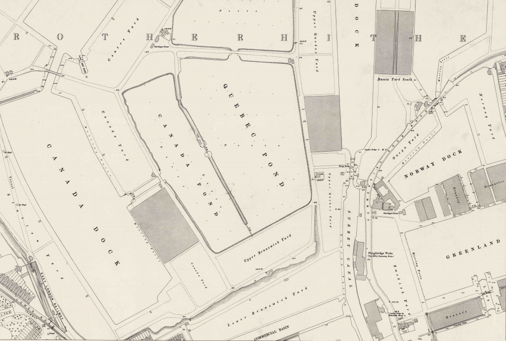
Canada Docks and Quebec Pond

[Originally published on Niche-Canada.org]


Canada Water is a small lake and wildlife refuge in the heart of Rotherhithe in South London. It is one of the few remaining parts of the once extensive Surrey Commercial Docks that covered much of the Rotherhithe Peninsula during the nineteenth century. Canada Water was Canada Dock, the centre of the timber trade in London, where timber was unloaded into the water and formed into rafts that were stored in Canada Pond and Quebec Pond (see the map below).

Map of Canada Dock, Canada Pond and Quebec Pond
London Sheet VII.99, David Rumsey Historical Map Collection
British Empire Dockyards and Ports, 1909 (Public Domain)

Liverpool’s Canada Dock, which was the centre of the timber trade on the Mersey River, remains intact and is still used to ship bulky commodities. The Canada Dock in Liverpool did not use storage ponds and instead the timber from Quebec, New Brunswick or the Baltic region (Russia, Sweden and Norway) was unloaded directly onto land. The threat of fire explained the remote location of the timber trade on the northern edge of the Port of Liverpool’s extensive network of docks.

Repurposing a Map of Greater London’s Industry (1893-5)

[Originally published on ActiveHistory.ca]
screencapturevisualization

A few years ago, I worked with some students to develop a database of all the factories we could find on very detailed 5 feet to the mile maps of London from the second half of the nineteenth century. This database is central to my academic research on the environmental history of industrialization in Greater London. I created maps using this historical GIS database for my first book and I’m busy working on a second major project with this spatial data at its centre. But I’ve also been thinking of how to make the HGIS data accessible and interesting to a wider public audience. I’ve created a number of interactive maps using Carto.com and StoryMaps and shared them over social media. Each time they are shared by other historians, but the statistics suggest they’ve not reached a large audience. I’m hoping this post might elicit suggestions from public historians on whether these interactive maps are worthy of more effort on my part to reach a wider audience and how I might succeed in doing so. Build it and they will come is clearly not working.

The Urban Environmental History of West Ham and the River Lea

[Originally published on the Global Urban History website: globalurbanhistory.com]

By Jim Clifford, University of Saskatchewan

Greater London’s population increased by five million during the nineteenth century and the city developed into a major center of industry, transforming the marshlands of the Thames Estuary into polluted and crowded urban landscapes. The rich collection of nineteenth-century London maps make digital mapping a powerful tool for exploring the environmental history of West Ham, the River Lea, and Greater London. The interactive map of factories digitized from the five feet to the mile Ordinance Survey, displays the historical Geographic Information Systems database at the core of my book West Ham and the River Lea: A Social and Environmental History of London’s Industrialized Marshland, 1839–1914.

800px-Silvertown_CWS_Flour_Mill

Image of the Co-operative Wholesale Society (CWS) flour mill in Silvertown, 1915 (Wikipedia)

Sliding between the early 1870s and the mid-1890s shows how factories migrated to the eastern suburbs as industry expanded in Greater London. West Ham was London’s most populous suburb and it became the center of Greater London’s industrial economy. The River Lea braided into multiple streams in West Ham, providing transportation for the coal barges that helped fuel a wide range of industries. Large factories also developed along the Thames, south of the docks, in a region called Silvertown. One of the nineteenth century’s most compelling examples of the relationship between environmental and social history comes together at the confluence of two rivers, where heavy industry and a population of more than a quarter of a million coexisted in an independent suburb. [read more]

West Ham and the River Lea: A Social and Environmental History of London’s Industrialized Marshland, 1839-1914

My book is published with the University of British Columbia Press. You can order the hardcopy for $75 or wait for the paperback in early 2018.

Here is the description from the press:

During the nineteenth century, London’s population grew by more than five million as people flocked from the countryside to the city to take up jobs in shops and factories. In West Ham and the River Lea, Jim Clifford explores the growth of London’s most populous independent suburb and the degradation of its second largest river, bringing to light the consequences of these developments on social democracy and urban politics in Greater London.

Drawing on Ordnance Surveys and archival materials, Jim Clifford uses historical geographic information systems to map the migration of Greater London’s industry into West Ham’s marshlands and reveals the consequences for the working-class people who lived among the factories. He argues that an unstable and unhealthy environment fuelled protest and political transformation. Poverty, pollution, water shortages, infectious disease, floods, and an unemployment crisis led the public to demand new forms of government intervention and provided an opening for new urban politics to emerge.

By exploring the intersection of pollution, poverty, and instability, Clifford establishes the importance of the urban environment in the development of social democracy in Greater London at the turn of the twentieth century.

This book will be of interest to scholars and students of London, the environment, and the history of political and social movements, as well as those interested in precursors to modern urban environmental politics.